What is UU spot?
UU Spot is a service which allows anyone to safely and easily find and view information relating to sightseeing spots in Hokkaido using a smartphone.
Currently the service stores the information of over 1500 sightseeing spots by coordinates.
It can be used for free anywhere in Hokkaido, by scanning the QR codes that appear in sightseeing texts, such as pamphlets in many cities, towns, and villages.
What you can do using it (supporting various languages)
- Sightseeing spots are displayed in order of proximity to the user's current location
- Check travel route
- Check additional information
- Travel obstacle information
*Please allow the location information of the smartphone.
How to use
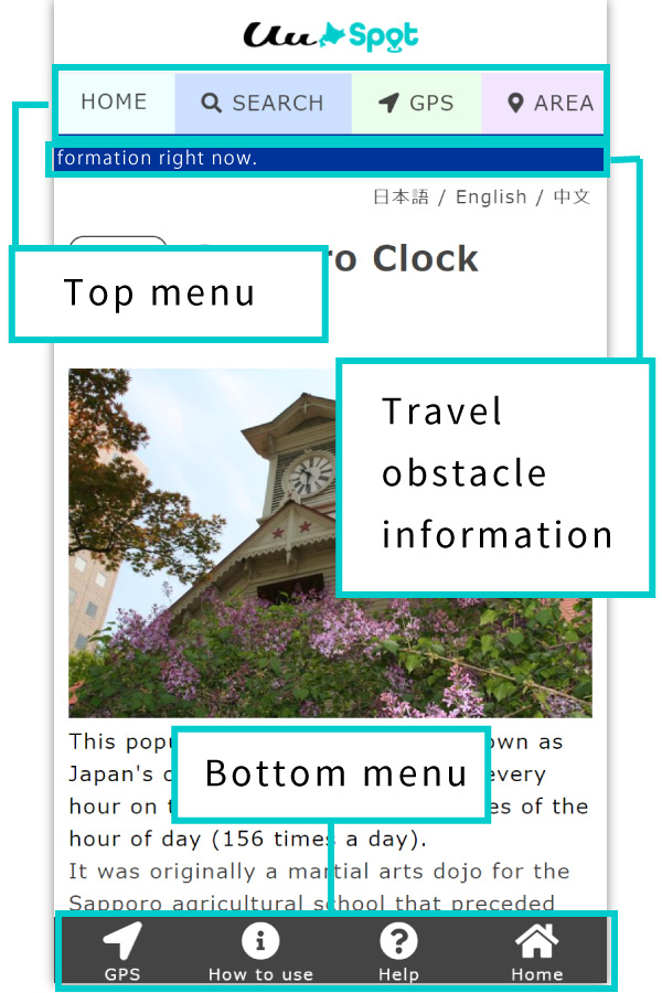
■Top menu
TOP
Navigate to top page.
SEARCH
The following searches are available.
・Keyword search
Sightseeing spots can be searched by keyword, MAPCODE, address, phone number, etc.
“マップコード” and “MAPCODE” are registered trademarks of DENSO Corporation.
・Search by map number
Search by the map number stated on the “UU Map” and “UU Travel Map”.
・Search by airport area/genre
The list of sightseeing spots can be narrowed down by each category. The search can also be filtered by airport area or genre.
GPS
Automatically collects and arranges sightseeing spots close to your current location. The list of sightseeing spots can be further filtered by the following five categories: Sightseeing, Transportation, Cuisine, Shopping, and Events.
AREA
Search for nearby sightseeing spots based on the seven airport areas: New Chitose Airport Area, Asahikawa Airport Area, Hakodate Airport Area, Wakkanai Airport Area ,Memanbetsu Airport Area , Kushiro Airport Area, and the Obihiro Airport Area.
GENRE
Search for tourist spots by genre including “Tourist Attractions” such as museums and aquariums, “Activities” such as cycling and horseback riding, and scenery such as “cherry blossoms” and “autumn leaves.”
TRAFFIC
Timetables for the following mentioned public transportation(Bus , train/JR, airport) are listed.
HELP
Jump to this page (How to use UU Spot).
■Travel obstacle information
Displaying information regarding suspension of service for railroads, airports etc. in the event of bad weather or obstructions to traffic, and guides you to a link to the target means of transportation.
■Bottom menu
*Not displayed on PC browsers
・GPS
Uses the “GPS(Nearby Spots)” function.
・How to use
Go to “How to use the Nearby Spots” on this page.
・Help
Go to the “Location information cannot be acquired” page.
・Home
Jump to UU Spot top page.
How to use "GPS(Nearby Spots)"
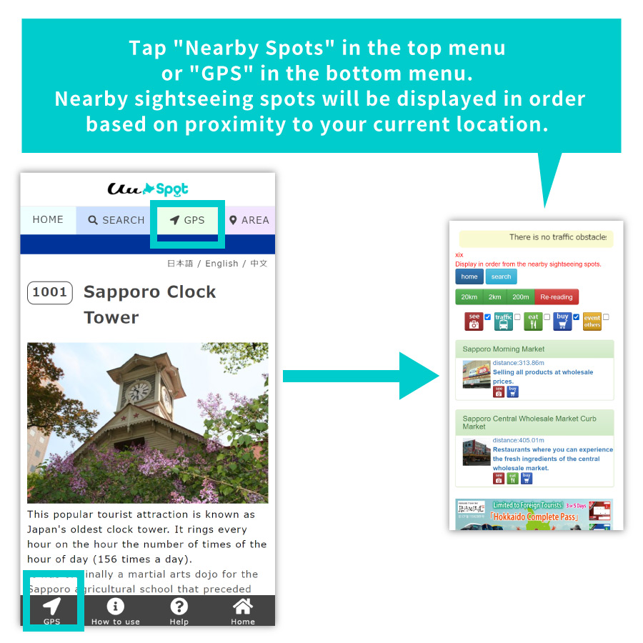
Tap “Nearby Spots” in the top menu or “GPS” in the bottom menu. Nearby sightseeing spots will be displayed in order based on proximity to your current location.
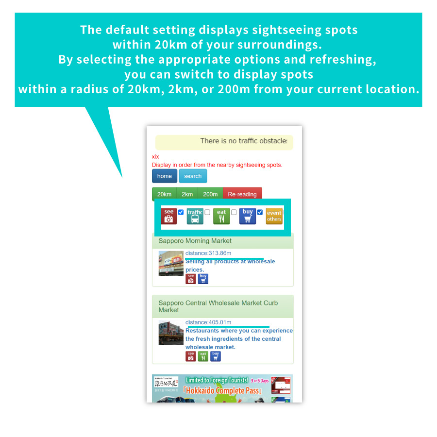
The default setting displays sightseeing spots within 20km of your surroundings. By selecting the appropriate options and refreshing, you can switch to display spots within a radius of 20km, 2km, or 200m from your current location.
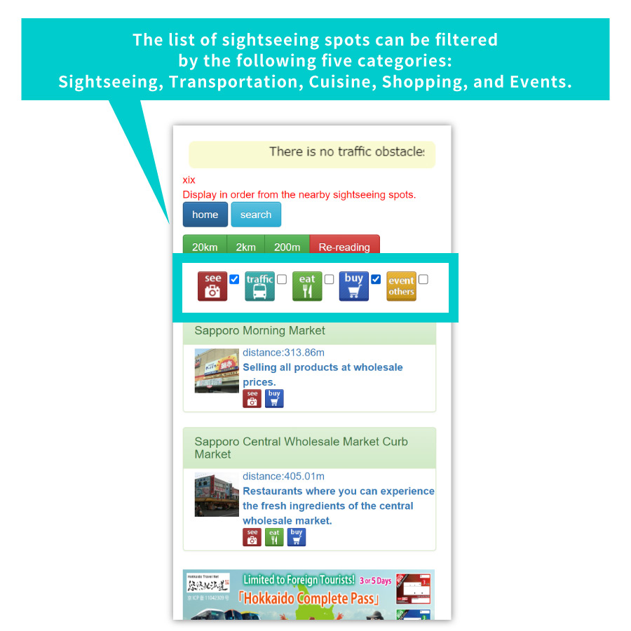
The list of sightseeing spots can be filtered by the following five categories: Sightseeing, Transportation, Cuisine, Shopping, and Events.
Precautions
●For this service , the area of use is within Hokkaido.
(Search may be utilized domestically or overseas)
●This service, Search do not function when out of reach of signal. The calculation for this service differs from actual distance. It does not account for actual winding roads, detours to bridges or altitude changes.
●It uses the positional information acquisition function of the smartphone. This function may be off. Please turn on positional information of your device in settings. Please also turn on the positional information in the browser.
●Supported browsers are Safari, Firefox, and Google Chrome.
Check the below if you cannot get location information.